

What are spatial data types in MySQL? How do you use them?

What are spatial data types in MySQL? How do you use them?
Spatial data types in MySQL are designed to store geometric data and perform operations on that data. MySQL supports several types of spatial data, each suited for different kinds of geometric information. The main spatial data types in MySQL include:
- POINT: Represents a single location in a two-dimensional Cartesian coordinate system, defined by its x and y coordinates.
- LINESTRING: Represents a curve, which may be a straight line between two points or a sequence of connected line segments.
- POLYGON: Represents a two-dimensional surface, which is a closed linestring with at least four points, where the first and last points are the same.
- MULTIPOINT: Represents a collection of points.
- MULTILINESTRING: Represents a collection of linestrings.
- MULTIPOLYGON: Represents a collection of polygons.
- GEOMETRYCOLLECTION: Represents a collection of any of the above geometric types.
To use these spatial data types in MySQL, you create columns of these types in your tables. For example:
CREATE TABLE locations (
    id INT AUTO_INCREMENT PRIMARY KEY,
    name VARCHAR(255),
    position POINT
);After defining the table, you can insert data into the spatial columns using special functions provided by MySQL:
INSERT INTO locations (name, position) VALUES ('Central Park', POINT(40.785091, -73.968285));MySQL also provides functions to manipulate and retrieve information from these spatial data types, such as ST_Distance to calculate the distance between two points.
What are the different types of spatial data supported by MySQL?
MySQL supports the following different types of spatial data:
- POINT: A single location in 2D space, defined by x and y coordinates.
- LINESTRING: A curve defined by multiple points that are connected in order.
- POLYGON: A surface defined by a closed linestring, forming a shape.
- MULTIPOINT: A collection of points, useful for representing multiple locations.
- MULTILINESTRING: A collection of linestrings, useful for representing paths or networks.
- MULTIPOLYGON: A collection of polygons, useful for representing complex areas with multiple disconnected parts.
- GEOMETRYCOLLECTION: A collection of any combination of the other geometric types, allowing for mixed types of geometric data.
These types are defined using the Open Geospatial Consortium (OGC) Simple Features Specification, which ensures compatibility with other systems and standards.
How can you perform spatial queries using MySQL's spatial functions?
MySQL provides a rich set of spatial functions that enable you to perform complex spatial queries. Some of the key functions include:
- ST_Contains(geom1, geom2): Returns 1 or 0 to indicate whether
geom1fully containsgeom2. - ST_Intersects(geom1, geom2): Returns 1 or 0 to indicate whether
geom1andgeom2have any point in common. - ST_Distance(geom1, geom2): Returns the minimum distance between
geom1andgeom2. - ST_Buffer(geom, distance): Returns a geometry that represents all points within a given distance from the input geometry.
Example of a spatial query to find all locations within a certain distance from a given point:
SELECT name, ST_Distance(position, POINT(40.7128, -74.0060)) AS distance
FROM locations
WHERE ST_Distance(position, POINT(40.7128, -74.0060)) < 10000;  -- Within 10,000 meters
This query calculates the distance of each location from the specified point and selects only those within 10,000 meters.
What are some practical applications of using spatial data types in MySQL databases?
Using spatial data types in MySQL can be beneficial in various real-world applications, including:
- Geographic Information Systems (GIS): Spatial data is essential for storing and analyzing geographic data, such as mapping applications, urban planning, and environmental monitoring.
- Location-Based Services (LBS): Applications like ride-sharing services, food delivery, and navigation systems rely on spatial data to track and calculate distances between users and service providers.
- Logistics and Supply Chain Management: Companies can optimize delivery routes, manage fleet operations, and plan warehouse locations using spatial data analysis.
- Real Estate and Property Management: Spatial data can help in analyzing property locations, plotting property boundaries, and visualizing neighborhood data.
- Public Safety and Emergency Services: Spatial data can be used for dispatching emergency services, analyzing crime patterns, and planning evacuation routes.
- Marketing and Sales: Companies can use spatial data for geotargeting, analyzing market penetration, and understanding demographic distributions.
- Agriculture: Farmers can use spatial data for precision farming, managing field boundaries, and optimizing irrigation and fertilization plans.
By leveraging spatial data types in MySQL, organizations can enhance their ability to store, query, and analyze geographic information, leading to better decision-making and improved operational efficiency.
The above is the detailed content of What are spatial data types in MySQL? How do you use them?. For more information, please follow other related articles on the PHP Chinese website!

Hot AI Tools

Undresser.AI Undress
AI-powered app for creating realistic nude photos

AI Clothes Remover
Online AI tool for removing clothes from photos.

Undress AI Tool
Undress images for free

Clothoff.io
AI clothes remover

Video Face Swap
Swap faces in any video effortlessly with our completely free AI face swap tool!

Hot Article
Hot Tools

Notepad++7.3.1
Easy-to-use and free code editor

SublimeText3 Chinese version
Chinese version, very easy to use

Zend Studio 13.0.1
Powerful PHP integrated development environment

Dreamweaver CS6
Visual web development tools

SublimeText3 Mac version
God-level code editing software (SublimeText3)
Hot Topics
 1658
1658
 14
1415
52
1309
25
1257
29
1231
24
14
1415
52
1309
25
1257
29
1231
24

 When might a full table scan be faster than using an index in MySQL?
Apr 09, 2025 am 12:05 AM
When might a full table scan be faster than using an index in MySQL?
Apr 09, 2025 am 12:05 AM
Full table scanning may be faster in MySQL than using indexes. Specific cases include: 1) the data volume is small; 2) when the query returns a large amount of data; 3) when the index column is not highly selective; 4) when the complex query. By analyzing query plans, optimizing indexes, avoiding over-index and regularly maintaining tables, you can make the best choices in practical applications.
 Can I install mysql on Windows 7
Apr 08, 2025 pm 03:21 PM
Can I install mysql on Windows 7
Apr 08, 2025 pm 03:21 PM
Yes, MySQL can be installed on Windows 7, and although Microsoft has stopped supporting Windows 7, MySQL is still compatible with it. However, the following points should be noted during the installation process: Download the MySQL installer for Windows. Select the appropriate version of MySQL (community or enterprise). Select the appropriate installation directory and character set during the installation process. Set the root user password and keep it properly. Connect to the database for testing. Note the compatibility and security issues on Windows 7, and it is recommended to upgrade to a supported operating system.
 MySQL: Simple Concepts for Easy Learning
Apr 10, 2025 am 09:29 AM
MySQL: Simple Concepts for Easy Learning
Apr 10, 2025 am 09:29 AM
MySQL is an open source relational database management system. 1) Create database and tables: Use the CREATEDATABASE and CREATETABLE commands. 2) Basic operations: INSERT, UPDATE, DELETE and SELECT. 3) Advanced operations: JOIN, subquery and transaction processing. 4) Debugging skills: Check syntax, data type and permissions. 5) Optimization suggestions: Use indexes, avoid SELECT* and use transactions.
 Can mysql and mariadb coexist
Apr 08, 2025 pm 02:27 PM
Can mysql and mariadb coexist
Apr 08, 2025 pm 02:27 PM
MySQL and MariaDB can coexist, but need to be configured with caution. The key is to allocate different port numbers and data directories to each database, and adjust parameters such as memory allocation and cache size. Connection pooling, application configuration, and version differences also need to be considered and need to be carefully tested and planned to avoid pitfalls. Running two databases simultaneously can cause performance problems in situations where resources are limited.
 RDS MySQL integration with Redshift zero ETL
Apr 08, 2025 pm 07:06 PM
RDS MySQL integration with Redshift zero ETL
Apr 08, 2025 pm 07:06 PM
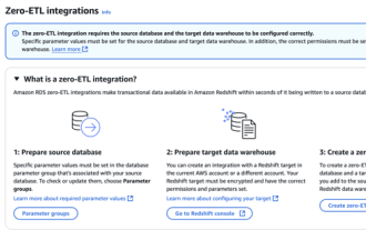
Data Integration Simplification: AmazonRDSMySQL and Redshift's zero ETL integration Efficient data integration is at the heart of a data-driven organization. Traditional ETL (extract, convert, load) processes are complex and time-consuming, especially when integrating databases (such as AmazonRDSMySQL) with data warehouses (such as Redshift). However, AWS provides zero ETL integration solutions that have completely changed this situation, providing a simplified, near-real-time solution for data migration from RDSMySQL to Redshift. This article will dive into RDSMySQL zero ETL integration with Redshift, explaining how it works and the advantages it brings to data engineers and developers.
 The relationship between mysql user and database
Apr 08, 2025 pm 07:15 PM
The relationship between mysql user and database
Apr 08, 2025 pm 07:15 PM
In MySQL database, the relationship between the user and the database is defined by permissions and tables. The user has a username and password to access the database. Permissions are granted through the GRANT command, while the table is created by the CREATE TABLE command. To establish a relationship between a user and a database, you need to create a database, create a user, and then grant permissions.
 Laravel Eloquent ORM in Bangla partial model search)
Apr 08, 2025 pm 02:06 PM
Laravel Eloquent ORM in Bangla partial model search)
Apr 08, 2025 pm 02:06 PM
LaravelEloquent Model Retrieval: Easily obtaining database data EloquentORM provides a concise and easy-to-understand way to operate the database. This article will introduce various Eloquent model search techniques in detail to help you obtain data from the database efficiently. 1. Get all records. Use the all() method to get all records in the database table: useApp\Models\Post;$posts=Post::all(); This will return a collection. You can access data using foreach loop or other collection methods: foreach($postsas$post){echo$post->
 MySQL: The Ease of Data Management for Beginners
Apr 09, 2025 am 12:07 AM
MySQL: The Ease of Data Management for Beginners
Apr 09, 2025 am 12:07 AM
MySQL is suitable for beginners because it is simple to install, powerful and easy to manage data. 1. Simple installation and configuration, suitable for a variety of operating systems. 2. Support basic operations such as creating databases and tables, inserting, querying, updating and deleting data. 3. Provide advanced functions such as JOIN operations and subqueries. 4. Performance can be improved through indexing, query optimization and table partitioning. 5. Support backup, recovery and security measures to ensure data security and consistency.
