

Mapping with Geocoder PHP and Leaflet.js


Interactive maps inside a web application have a lot of great uses. From visualizing data to highlighting points of interest, maps are expected to communicate ideas within the context of location easily.
The hardest part, however, is converting that data into coordinates that the map can understand. Luckily, Geocoder PHP allows us to connect to different geo-coding providers. Combined with Leaflet.js, a simple Javascript library, creating maps is a breeze.
Key Takeaways
- Geocoder PHP and Leaflet.js can be effectively combined to create interactive maps within a web application, converting data into coordinates that the map can comprehend easily.
- The Geocoder library allows for the connection to different geo-coding providers and the ability to switch out your adapter if your needs change, without having to rewrite how your application receives the data.
- Leaflet.js is a powerful Javascript library that makes mapping easy by handling the interaction layer of the maps, including creating individual markers and formatting the array of data in a way Leaflet expects.
- The appearance and interactivity of the map can be customized using various Leaflet JS options and functions, and the data for these features can be fetched from a database using PHP and then passed to the Leaflet JS functions.
Starting
With Composer, including the Geocoder PHP library is simple:
{
  "require": {
    "willdurand/geocoder": "*"
  }
}Let’s also add some html to a simple index.php file to include Bootstrap so that we have a nice-looking environment to display our map in:
<?php
require 'vendor/autoload.php';

?>
<!DOCTYPE html>
<html>
<head>
    <title>A simple map with Geocoder PHP and Leaflet.js</title>
    <meta name="viewport" content="width=device-width, initial-scale=1.0">
    <link rel="stylesheet" href="//netdna.bootstrapcdn.com/bootstrap/3.0.0/css/bootstrap.min.css">
</head>
<body>
<div >
    <div >
        <div >
            <h1 >A simple map with Geocoder PHP and Leaflet.js</h1>
        </div>
        <div >
            <div >

            </div>
        </div>
    </div><!-- /row -->
</div> <!-- /container -->
<script></script>
<script src="//netdna.bootstrapcdn.com/bootstrap/3.0.0/js/bootstrap.min.js"></script>
</body>
</html>Setting Up Geocoder
Geocoder bills itself as the missing the geocoder library for PHP. It can be used in three simple steps:
- Register an adapter
- Register a provider
- Geocode!
Register an Adapter
The adapter serves as the mechanism to connect and get data to your chosen provider via their API. Some adapters use the built-in functionality within PHP 5.3 , like cURL and sockets. Others, like Buzz, Guzzle, and Zend HTTP Client, use third-party open source libraries that simply require you to add their dependency to your composer file.
The beauty of the Geocoder library is this abstraction of the adapter step. It allows you swap out your adapter if your needs change without requiring you to rewrite how your application receives the data.
For this example, we’re going to use cURL and the included CurlHTTPAdapter class inside the Geocoder PHP library.
In our index.php file, let’s add the adapter:
// Setup geocoder adapter.
$adapter = new \Geocoder\HttpAdapter\CurlHttpAdapter();
Register a provider
There are many geocoding providers that are supported out-of-the-box by the Geocoder PHP library, including Google Maps, Bing Maps, Nominatim via Openstreetmap, and TomTom.
The full list can be found on the README of the Geocoder PHP repository.
Each provider, as represented by its respective classes, has its own options. Depending on your needs, you can register multiple providers for various circumstances. This may be useful if your application needs to map specific streets in San Jose, Costa Rica using Openstreetmap and find a quick route in Beijing, China using Baidu.
For this example, I’ll simply use Google Maps, but register it in a way that if I want to add another provider in the future, I simply need to add it to an array:
{
  "require": {
    "willdurand/geocoder": "*"
  }
}Geocode
We can now pass the address to the geocode() method inside your newly instantiated $geocoder object. This will return a result object that is instantiated through the provider chosen earlier. This result object has getLatitude() and getLongitude() methods we can use.
<?php
require 'vendor/autoload.php';

?>
<!DOCTYPE html>
<html>
<head>
    <title>A simple map with Geocoder PHP and Leaflet.js</title>
    <meta name="viewport" content="width=device-width, initial-scale=1.0">
    <link rel="stylesheet" href="//netdna.bootstrapcdn.com/bootstrap/3.0.0/css/bootstrap.min.css">
</head>
<body>
<div >
    <div >
        <div >
            <h1 >A simple map with Geocoder PHP and Leaflet.js</h1>
        </div>
        <div >
            <div >

            </div>
        </div>
    </div><!-- /row -->
</div> <!-- /container -->
<script src="https://img.php.cn/ajax.googleapis.com/ajax/libs/jquery/1.10.2/jquery.min.js"></script>
<script src="//netdna.bootstrapcdn.com/bootstrap/3.0.0/js/bootstrap.min.js"></script>
</body>
</html>Integrating with Leaflet.js
Leaflet.js is a powerful javascript library that makes mapping very easy.
Maps consist of three parts:
- Tiles
- Interaction layer (typically through Javascript and CSS)
- Data points
The tiles are the 256 by 256 pixel squares that show the map detail. Services like Mapbox and Cloudmade allow you to create your own tilesets. For this example, I’ve created a free account with Cloudemade and will use the API key given to show tiles from their hosting service.
The interaction layer is handled by Leaflet.js. I simply include the Leaflet Javascript and CSS library into our starter HTML template:
// Setup geocoder adapter.
$adapter = new \Geocoder\HttpAdapter\CurlHttpAdapter();
The data points have been created earlier with my geocoder code. I simply have to format the array of data in a way Leaflet expects.
In this simple example, I’m simply going to create individual markers as Javascript variables that will be included in my map via strings produced by PHP.
Leaflet has the option for this data to also be passed in via the geoJSON format for larger and more dynamic datasets.
// Create a chain of providers.
// Be sure to include my previously created adapter.
$chain = new \Geocoder\Provider\ChainProvider(
    array(
        new \Geocoder\Provider\GoogleMapsProvider($adapter),
    )
);

// Instantiate the geocoder.
$geocoder = new \Geocoder\Geocoder();

// Register my providers.
$geocoder->registerProvider($chain);Because Leaflet injects the map code into an existing DOM element, we first have to define that element inside our HTML. We can do this by simply creating a div with a unique id:
We can then target that id in Leaflet by calling the built-in map() Javascript method and pass in our id in the footer:
// Demo locations
$locations = array(
    array(
        'address' => '3324 N California Ave, Chicago, IL, 60618',
        'title' => 'Hot Dougs',
    ),
    array(
        'address' => '11 S White, Frankfort, IL, 60423',
        'title' => 'Museum',
    ),
    array(
        'address' => '1000 Sterling Ave, , Flossmoor, IL, 60422',
        'title' => 'Library',
    ),
    array(
        'address' => '2053 Ridge Rd, Homewood, IL, 60430',
        'title' => 'Twisted Q',
    )
);

foreach ($locations as $key => $value) {
    // Try to geocode.
    try {
        $geocode = $geocoder->geocode($value['address']);
        $longitude = $geocode->getLongitude();
        $latitude = $geocode->getLatitude();

    } catch (Exception $e) {
        echo $e->getMessage();
    }
}Now, we build the three parts of our map. To register the tiles, we simply call the built-in tileLayer() method, defining attributes and zoom level if desired, then appending the addTo() method:
<link rel="stylesheet" href="//cdn.leafletjs.com/leaflet-0.6.4/leaflet.css" />
<script src="//cdn.leafletjs.com/leaflet-0.6.4/leaflet.js"></script>
Finally, we print our map data using the PHP array we defined earlier, and make sure the map centers itself on those data points by defining them together as group. All in all, the Javascript in the footer would be:
$mapdata = $marker_group = array();

foreach ($locations as $key => $value) {
    // Try to geocode.
    try {
        $geocode = $geocoder->geocode($value['address']);
        $longitude = $geocode->getLongitude();
        $latitude = $geocode->getLatitude();

        // Create map data array
        $mapdata[] = markerCreator($latitude, $longitude, $value['title'], $key);

        // Marker grouping array
        $marker_group[] = "marker{$key}";

    } catch (Exception $e) {
        echo $e->getMessage();
    }
}

function markerCreator($lat, $long, $label, $key) {
    return "var marker{$key} = L.marker([{$lat}, {$long}]).addTo(map);
    marker{$key}.bindPopup(\"{$label}\");";
}If you’ve gotten this far, you’ll notice that nothing happens.
This is because Leaflet does not inject properties on the height or width of the map div, allowing you to style it and resize it as you please. Simply give your div a height and width, and your map should appear!
Conclusion
You can create beautiful, interactive maps with the Geocoder PHP library and Leaflet.js. Be sure to check out the respective documentation of each project as there are many more advanced customizations that are possible.
Check out the demo for this article or fork it over at Github.
Frequently Asked Questions (FAQs) about Mapping with Geocoder PHP and Leaflet JS
How Can I Integrate Leaflet JS with PHP?
Integrating Leaflet JS with PHP involves a few steps. First, you need to include the Leaflet JS library in your PHP file. This can be done by downloading the library and linking it in your PHP file or by using a CDN. Once the library is included, you can initialize a map using the L.map() function. You can then add layers, markers, and other features to the map using various Leaflet JS functions. The data for these features can be fetched from a database using PHP and then passed to the Leaflet JS functions.
What is Geocoding and How is it Used in Leaflet JS?
Geocoding is the process of converting addresses into geographic coordinates, which you can use to place markers on a map, or position the map. In Leaflet JS, you can use a geocoding service like Nominatim or Google’s Geocoding API to convert addresses into coordinates. Once you have the coordinates, you can use the L.marker() function to place a marker on the map at the specified coordinates.
How Can I Use PHP to Fetch Data from a Database for My Map?
PHP can be used to fetch data from a database by using its built-in functions for database interaction. For example, if you’re using a MySQL database, you can use the mysqli_connect() function to connect to the database, and then use the mysqli_query() function to execute a SQL query and fetch data. The fetched data can then be passed to the Leaflet JS functions to add features to the map.
How Can I Add Interactive Features to My Map?
Leaflet JS provides various functions to add interactive features to your map. For example, you can use the L.popup() function to add popups to your map, which can display additional information when a marker or other feature is clicked. You can also use the L.control.layers() function to add a layers control, which allows users to switch between different base layers and overlay layers.
How Can I Customize the Appearance of My Map?
The appearance of your map can be customized using various Leaflet JS options and functions. For example, you can use the setView() function to set the initial geographic center and zoom level of the map. You can also use the L.tileLayer() function to add a tile layer to the map, which determines the visual appearance of the map’s base layer. The options parameter of the L.map() function can be used to set various other options, such as the map’s maximum zoom level, whether to display attribution control, and so on.
How Can I Handle Errors When Using Geocoding Services?
When using geocoding services, errors can occur for various reasons, such as network issues, invalid input, or exceeding the service’s usage limits. These errors can be handled by using error handling techniques provided by the programming language you’re using. For example, in PHP, you can use the try-catch statement to catch exceptions and handle them appropriately.
How Can I Optimize the Performance of My Map?
There are several ways to optimize the performance of your map. One way is to use a tile layer that is optimized for performance, such as a vector tile layer. Another way is to limit the number of features displayed on the map at once, for example by using clustering or by only displaying features within the current map view. You can also optimize the performance of your PHP code by using efficient database queries and by caching results when appropriate.
How Can I Make My Map Responsive?
Making your map responsive involves ensuring that it displays correctly on different screen sizes and devices. This can be achieved by using CSS media queries to adjust the size and layout of the map container based on the screen size. You can also use the Leaflet JS map.invalidateSize() function to update the map’s size and position when the size of its container changes.
How Can I Add Custom Markers to My Map?
Custom markers can be added to your map by using the L.icon() function. This function allows you to specify a custom image to be used as the marker icon. You can also specify the size, anchor point, and other properties of the icon. The custom icon can then be used when creating a marker by passing it as an option to the L.marker() function.
How Can I Use Leaflet JS to Display Data from a GeoJSON File?
Leaflet JS provides the L.geoJSON() function, which can be used to display data from a GeoJSON file on your map. This function takes a GeoJSON object as input and creates a layer containing the features described by the GeoJSON data. The features can be styled and interacted with using various options and methods provided by the L.geoJSON() function. The GeoJSON data can be fetched from a file or a server using PHP or JavaScript.
The above is the detailed content of Mapping with Geocoder PHP and Leaflet.js. For more information, please follow other related articles on the PHP Chinese website!

Hot AI Tools

Undresser.AI Undress
AI-powered app for creating realistic nude photos

AI Clothes Remover
Online AI tool for removing clothes from photos.

Undress AI Tool
Undress images for free

Clothoff.io
AI clothes remover

Video Face Swap
Swap faces in any video effortlessly with our completely free AI face swap tool!

Hot Article
Hot Tools

Notepad++7.3.1
Easy-to-use and free code editor

SublimeText3 Chinese version
Chinese version, very easy to use

Zend Studio 13.0.1
Powerful PHP integrated development environment

Dreamweaver CS6
Visual web development tools

SublimeText3 Mac version
God-level code editing software (SublimeText3)
Hot Topics
 1664
1664
 14
1423
52
1317
25
1268
29
1248
24
14
1423
52
1317
25
1268
29
1248
24

 The Evolution of JavaScript: Current Trends and Future Prospects
Apr 10, 2025 am 09:33 AM
The Evolution of JavaScript: Current Trends and Future Prospects
Apr 10, 2025 am 09:33 AM
The latest trends in JavaScript include the rise of TypeScript, the popularity of modern frameworks and libraries, and the application of WebAssembly. Future prospects cover more powerful type systems, the development of server-side JavaScript, the expansion of artificial intelligence and machine learning, and the potential of IoT and edge computing.
 JavaScript Engines: Comparing Implementations
Apr 13, 2025 am 12:05 AM
JavaScript Engines: Comparing Implementations
Apr 13, 2025 am 12:05 AM
Different JavaScript engines have different effects when parsing and executing JavaScript code, because the implementation principles and optimization strategies of each engine differ. 1. Lexical analysis: convert source code into lexical unit. 2. Grammar analysis: Generate an abstract syntax tree. 3. Optimization and compilation: Generate machine code through the JIT compiler. 4. Execute: Run the machine code. V8 engine optimizes through instant compilation and hidden class, SpiderMonkey uses a type inference system, resulting in different performance performance on the same code.
 Python vs. JavaScript: The Learning Curve and Ease of Use
Apr 16, 2025 am 12:12 AM
Python vs. JavaScript: The Learning Curve and Ease of Use
Apr 16, 2025 am 12:12 AM
Python is more suitable for beginners, with a smooth learning curve and concise syntax; JavaScript is suitable for front-end development, with a steep learning curve and flexible syntax. 1. Python syntax is intuitive and suitable for data science and back-end development. 2. JavaScript is flexible and widely used in front-end and server-side programming.
 JavaScript: Exploring the Versatility of a Web Language
Apr 11, 2025 am 12:01 AM
JavaScript: Exploring the Versatility of a Web Language
Apr 11, 2025 am 12:01 AM
JavaScript is the core language of modern web development and is widely used for its diversity and flexibility. 1) Front-end development: build dynamic web pages and single-page applications through DOM operations and modern frameworks (such as React, Vue.js, Angular). 2) Server-side development: Node.js uses a non-blocking I/O model to handle high concurrency and real-time applications. 3) Mobile and desktop application development: cross-platform development is realized through ReactNative and Electron to improve development efficiency.
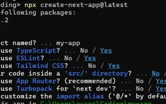 How to Build a Multi-Tenant SaaS Application with Next.js (Frontend Integration)
Apr 11, 2025 am 08:22 AM
How to Build a Multi-Tenant SaaS Application with Next.js (Frontend Integration)
Apr 11, 2025 am 08:22 AM
This article demonstrates frontend integration with a backend secured by Permit, building a functional EdTech SaaS application using Next.js. The frontend fetches user permissions to control UI visibility and ensures API requests adhere to role-base
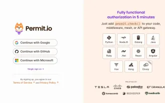 Building a Multi-Tenant SaaS Application with Next.js (Backend Integration)
Apr 11, 2025 am 08:23 AM
Building a Multi-Tenant SaaS Application with Next.js (Backend Integration)
Apr 11, 2025 am 08:23 AM
I built a functional multi-tenant SaaS application (an EdTech app) with your everyday tech tool and you can do the same. First, what’s a multi-tenant SaaS application? Multi-tenant SaaS applications let you serve multiple customers from a sing
 From C/C to JavaScript: How It All Works
Apr 14, 2025 am 12:05 AM
From C/C to JavaScript: How It All Works
Apr 14, 2025 am 12:05 AM
The shift from C/C to JavaScript requires adapting to dynamic typing, garbage collection and asynchronous programming. 1) C/C is a statically typed language that requires manual memory management, while JavaScript is dynamically typed and garbage collection is automatically processed. 2) C/C needs to be compiled into machine code, while JavaScript is an interpreted language. 3) JavaScript introduces concepts such as closures, prototype chains and Promise, which enhances flexibility and asynchronous programming capabilities.
 JavaScript and the Web: Core Functionality and Use Cases
Apr 18, 2025 am 12:19 AM
JavaScript and the Web: Core Functionality and Use Cases
Apr 18, 2025 am 12:19 AM
The main uses of JavaScript in web development include client interaction, form verification and asynchronous communication. 1) Dynamic content update and user interaction through DOM operations; 2) Client verification is carried out before the user submits data to improve the user experience; 3) Refreshless communication with the server is achieved through AJAX technology.
